Gitaro.JIM Project Website

Multi-physics Integration

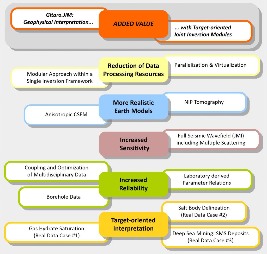
Geophysical interpretation with target-oriented Joint Inversion Modules
for an environmentally friendly resource exploitation of the seafloor
by optimized processing, realistic earth models and increased sensitivity & reliability.

Motivation & Objectives

The goal of this collaboration project is to integrate multi-disciplinary geophysical data sets in a modular joint inversion approach. The complementary data reduces ambiguities of structural earth models while the modular scheme takes advantage of individual solutions in geophysical exploration and exploitation of conventional and unconventional submarine resources. The resulting improvement to the resource assessment can lead to more efficient and cost-effective data acquisition, interpretation and reduced drilling.

Methods & Tools

The consortium is led by two enterprises (SMEs) cooperating interdisciplinary with European academic and industry partners. Based on a core Joint Inversion framework, individual modules for Controlled Source Electromagnetics (CSEM), seismic Joint Migration Inversion (JMI), gravity & magnetics (G/M), and well data will be developed. It is planned to assess uncertainties in modelling and effects of anisotropy, investigate CSEM sensitivities and develop a toolbox of different coupling strategies. Laboratory tests on anisotropy using electrical resistivity and seismic tomography support model developments and case studies.

Applications & Benefits

Applying case studies using real data from partners and possible clients increases credibility as well as awareness of the ongoing developments, which foster know-how of strategies and coupling in integrated geophysical data processing and interpretation. As a spin-off newly developed laboratory technique will be developed further. By integrating CSEM and G/M, which are non-destructive, noise-free methods applicable in sensitive regions, the work may contribute, stimulate and accelerate the development of sustainable technology in the exploitation of unconventional resources.

Integrated geophysical interpretation

Added Value

When considering maritime challenges for the future, energy and environmental topics are at the top of the list, as both are of transnational relevance.

Thus we require adequate approaches and solutions beyond national barriers.

With this project we develop tools within an open and flexible framework on a European level by joining forces of individual expertise in an integrated way.

From the technical point of view, we have to address different targets (deep sea mining, gas hydrates, fossil fuels) in different geological settings by utilizing different geophysical workflows – under environmentally sustainable conditions.

Here the basic approach is to jointly interpret the different subsurface models, which are derived from different geophysical measurements.

The key point is that each partner’s expertise can contribute towards a unified solution in a way that the integrated interpretation is more valuable than the sum of their individual results, in terms of precision, reliability and risk reduction; thus, representing a true added value.

Environmentally friendly resource exploitation of the seafloor requires the development of reliable earth models of the chosen site and reliable indications of the quantity of contained resources. Meeting these criteria will lead to a more focused exploitation with a higher success rate and thereby reduce the environmental impact in terms of data acquisition, seafloor drilling or extensive seafloor sampling in case of oil and gas exploration and deep sea mining.

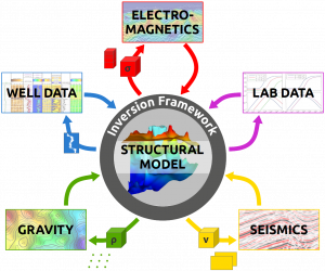
A key aspect is an intelligent integration of multidisciplinary geophysical datasets. Each geophysical dataset contains information about the underlying earth, yet the information content differs. Ambiguities of the earth models derived by data inversion exist for each method owing to the physics of the method and to limited amounts of data acquired at discrete sites on the seafloor surface. Also, different physical properties contain different information about the subsurface resource potential.

Addressing the future marine exploration requirements

Working in complex geological settings requires a modular toolbox of integrated geophysical techniques

The Joint Inversion Framework

Each geological setting has specific target related problems. Individual combinations of existing a-priori knowledge with various field datasets require a highly modular approach for an integrated interpretation based on a combined data analysis and inversion. Multiple methods of coupling and constraining inversion results will help to customize to the specific tasks. The applications are chosen with a large bandwidth of exploration tasks in marine environments. This ensures an exposure of the inversion method to a diversity of problems and provides working examples in a broad application range.

Target-oriented Multi-Physics Workflows

Applications in European Waters

Methane Hydrates
Danube Paleo Delta, Black Sea

The exploration and exploitation of gas-hydrate occurrences in the paleo-delta of the Danube in the Black Sea are investigated in the SUGAR-III project finalizing in March 2018. Sediments of the Danube Delta have been deposited for the last 900k years. The glaciation history of the delta led to 8 sequences in the deeper paleo-delta (up to 2200 m water depth) while the recent sedimentation at higher water levels is largely restricted to the shelf area. The related sediments on the upper and middle slope hold various structures of deep sea fans, including stacked channel-levee systems and mass transport deposits. The organic rich sediments of the enclosed environment in the Black Sea serve as source for methane and the layered delta sediments as a possible reservoir for gas hydrates. Currently, suitable conditions exist at water depths below ca. 665m. Sandy sediments found in channel-levee systems within the deep paleo-delta are currently under investigation for gas hydrate reservoirs as part of the SUGAR III project.


A complex salt delineation for oil & gas exploration in the Nordkapp Basin, Barents Sea, has led to intensive multi-parameter interpretation of individual datasets from 3D seismics, CSEM, magnetotelluric (MT) and gravity and gravity-gradient (FTG) data. The intra-continental syn-rift salt basin was believed to build salt-related traps as main hydrocarbon play. After drilling the expected traps could not be verified and post-drilling acquisition and analysis of multi-parameter datasets was initiated.


Fossil Fuels – Oil & Gas
Nordkapp Basin, Barents Sea

In conclusion of the current research the salt delineation is very different to the first indication by interpretation from seismic measurements alone. The abundance of industrially acquired multi-parameter data yields the potential to ideally demonstrate the power of automated interdisciplinary multi-parameter inversion. Thus, this prospect will be best suited to develop and test the proposed methods and their integration into the joint inversion framework.


At Palinuro, up to 5m of SMS were recovered in drilling cores, partially covered by several meters of sediments, with little to no hydrothermal activity being observed. This hydrothermally inactive seamount was used for the testing of new electromagnetic instrumentation: measurements with the novel MARTEMIS system helped to outline the zone of mineralization, and detected a second, previously unknown zone of potential mineralization. Furthermore, measurements of the ambient electrical field and a novel Coil2Dipole experiment yielded additional information about outline and depth extent of the mineralization. All methods are noise and vibration free and allow for the robust and efficient detection and characterization of SMS. The joint interpretation of these datasets will aim to yield a comprehensive 3D picture of the zone of mineralization, which would be a general prerequisite for the environmental-friendly exploitation of deep sea resources. Additionally, the suitability of available seismic data (surface towed streamer data + stationary OBS receivers) for structural investigations within the JI framework may be investigated.


Seefloor Massive Sulfides
Palinuro, Tyrrhenian Sea

Summarized value of the Joint Inversion framework

Gitaro.JIM

A fast performance of the JI software is ensured by SW engineering providing a parallel and virtualized code and by flexible user control adjusting the active modules exactly to the scope of data in the given project.

In correspondence to the available data, realistic basic long-wavelength earth models are consistently provided by anisotropic CSEM and NIP tomography from electromagnetic and seismic data, plus additional model characteristics from gravity and magnetic data.

Structural details of the subsurface are revealed by the Joint Migration Inversion (JMI) from the full seismic wavefield, exploiting the seismic data beyond the conventional primary reflections by recovering additional valuable illumination through multiples.

Site-specific physical and empirical relations are derived from borehole data and laboratory investigations and inserted into the joint inversion.

Several case studies demonstrate this workflow to potential users, investigating different exploration targets like gas-hydrates, hydrocarbons in salt tectonics, and seafloor massive sulfide deposits.

Project Partners

Expert Cooperation

The consortium consists of two German industrial SMEs, TEEC GmbH and TERRASYS Geophysics, intending to provide a new collaborative service based on the development of the proposed project. Academic research institutions GEOMAR, GFZ (DE) and the Technical University of Delft (NL) provide the know-how required for the proposed developments; just like the DELPHI consortium which has been sponsored by TEEC in recent years. Equinor (formerly Statoil) (NO) and the University of Southampton (UK) contribute as associate partners.


The consortium is led by TEEC. As the coordinator of the sub-project 1 in the SUGAR consortium, the worldwide operating service company TEEC has the required capacity to fulfill this role. The independent research division TEECware GmbH will contribute as a subcontractor with its more than 15 years of expertise in software development for high-performance computing in seismic processing & imaging. TEEC’s services, based on unique technical approaches and 25 years of experience, is requested worldwide by Oil&Gas companies due to the superior solutions to special problems.


This also applies to TERRASYS Geophysics with 25 years of expertise in potential field methods and Joint Inversion. TERRASYS provides consulting services for worldwide projects in different tectonic settings. For a flexible approach in-house software is developed, particularly the JI framework InvertMaster, which was extended during the SUGAR project. It features multiple structural and grid-based parameterizations, gravity and magnetics modules, interfaces to other forward modelling tools, versatile handling of geological constraints, and comprehensive assessment of statistical properties of the results.

In the past decade the electromagnetic workgroup at GEOMAR has built CSEM instrumentation and has acquired datasets worldwide on various geological targets with special focus on gas-hydrates and seafloor massive sulfides. For the interpretation of CSEM data the group has developed a fast time-domain 3D modeling code, which was recently extended to also handle the inverse problem. While the JI of combined geophysical datasets (MT, gravity, seismic arrival times) is well established in the working group, the JI integration of CSEM measurements is a current focus in cooperation with partners of this consortium.
Technische Universiteit Delft is the largest Dutch university of technology. The section of Applied Geophysics and Petrophysics at the Department of Geoscience & Engineering of the Faculty of Civil Engineering and Geosciences is involved in many disciplinary and multi-disciplinary research projects on topics that are relevant to the present proposal. This includes advanced imaging and inversion technologies, acoustic, elastic, and electromagnetic characterization at different spatial-temporal scales, using seismic data, CSEM methods and ground-penetrating radar for different applications, including hydrocarbon reservoirs.

Geoforschungszentrum Potsdam (GFZ)’s hydrate group is very experienced in experimental studies on thermodynamic properties of hydrates and physical properties of hydrate-bearing sediments. GFZ runs specially designed, unique equipment to study those properties under simulated in situ pressure and temperature conditions (LARS, SEPP). Key features are the electrical and sonic tomographic systems to image the resistivity and velocity distribution inside the pilot plant LARS at large-scale samples. State-of-the-art equipment is available to determine permeability, porosity, sediment grain size distribution, and to perform mineralogical/ geochemical sediment analysis.

University of Southampton provides measuring time for their Gas Hydrate Resonant Column Apparatus, where the shear modulus, G, and damping ratio, D which relate to the seismic propagation, can be determined for synthetic methane hydrates specimen.

Equinor (formerly Statoil) provides relevant multi-physics datasets for the applications and receives the respective inversion results, particularly for the Barents Sea area.